Please find attached the latest Flood Summary Sheet for Shropshire, Herefordshire, Worcestershire, and Gloucestershire.
Please note, from 10:00 Saturday 19 October 2024, we will be reverting to updating the Summary Sheet daily from 10:00.
Weather summary: Friday night will see a weak front moving east bringing rain this afternoon. This could be heavy overnight with possible line convection into Saturday morning. Totals from this rain are not forecast to cause any new fluvial flooding impacts, with totals of 5mm average and potential isolated totals of 10-15mm. There are worst case figures of 25mm should rainfall events align. Saturday is set to be dry once the overnight rain has cleared.
Sunday will see a deep low-pressure system move across the patch from West to East that will bring strong winds. However, rainfall totals are again quite low with only minor fluvial impacts currently expected. 5-10mm of rainfall is expected catchment wide with the possibility of 15mm spot totals.
Impacts are expected to be greatest on Southwest facing slopes and 1 or 2 more alerts may be required from this forecast rain on the Teme and Wye.
Fluvial summary: Hayes basin is now full, and levels are rising down the Severn. Levels are steadily dropping on the Team and Wye.
Operational activity:
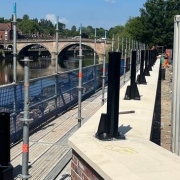
• Phase 1 and 2 in place in Shrewsbury – Frankwell.
• Phase 1 at Ironbridge is being erected today – this is not going to be sheeted due to forecast levels and high winds on Sunday.
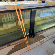
• At Bewdley Severnside phase 1 (Severnside North) is in place, Severn Side South is being deployed now and will be completed today.
• Hylton road pumps are in place in Worcester and Kempsey pumps are operational.
• All Upton gates are closed except Dunns Lane. We are planning to close Dunns lane gate this afternoon, as necessary.
Tides: Tides are rising due to springs with the highest astro tides forecast for Friday evening. There is a chance that Sunday’s tides will also be high due to low pressure and high winds forecast over the weekend. At low tide, levels will recede to below alert thresholds for Gloucester and Sharpness but remain above flood alert level for Haw Bridge and Tewkesbury/The Mythe. Gloucester 3.6-3.9m This evening and 3.8-4.1 tomorrow morning. Sharpness 10.2-10.5 tonight and 9.9-10.3 tomorrow morning.
Many thanks,
Emma Musgrove
Flood Warning Duty Officer
Flood Summary Sheet for West Midlands Area
(Shropshire, Herefordshire, Worcestershire and Gloucestershire) |
|
| Time: |
17:00 |
Date: |
18/10/2024 |
Next Update Planned (approximately): |
19/10/2024 10:00 |
|
|
|
|
| Section 1: Warnings in Force |
|
Flood Alerts |
Flood Warnings |
Severe Flood Warnings |
| For full details of Warnings currently in force please visit: |
Check for flooding in England (gov.uk) |
|
| Section 2: River Level Information |
| River |
Gauge Location |
Forecast |
Forecast |
Forecast Date and Time of Peak |
|
Recorded |
Recorded Time of Peak |
Highest peak in last 5 years (m) |
Highest Historic Peak (m) |
| Minimum |
Maximum |
Peak |
| Severn |
Crew Green |
|
|
|
|
6.25 |
Thursday AM |
6.58 |
22-Feb-22 |
6.58 |
21-Feb-22 |
| Welsh Bridge |
3.40 |
3.60 |
Friday PM |
|
|
|
5.15 |
22-Feb-22 |
5.25 |
01-Nov-00 |
| Buildwas |
4.70 |
5.00 |
Sat AM |
|
|
|
6.71 |
23-Jan-21 |
7.04 |
02-Nov-00 |
| Bridgnorth |
4.00 |
4.40 |
Sat PM |
|
|
|
5.15 |
23-Nov-21 |
5.26 |
02-Nov-00 |
| Bewdley |
3.90 |
4.20 |
Sat PM |
|
|
|
5.44 |
23-Jan-21 |
5.56 |
02-Nov-00 |
| Worcester |
4.80 |
5.30 |
Sat – Sun Overnight |
|
|
|
5.74 |
24-Jan-21 |
5.79 |
26-Feb-20 |
| Diglis |
4.30 |
4.60 |
Sat – Sun Overnight |
|
|
|
5.27 |
17-Feb-20 |
5.30 |
21-Jul-07 |
| Kempsey Yacht Club |
6.90 |
7.30 |
Fri-Sat Overnight |
|
|
|
7.49 |
17-Feb-20 |
7.49 |
17-Feb-20 |
| Saxons Lode |
4.80 |
5.20 |
Sat AM |
|
|
|
5.49 |
17-Feb-20 |
5.93 |
22-Jul-07 |
| Mythe |
4.20 |
4.50 |
Sunday |
|
|
|
4.83 |
04-Jan-24 |
5.50 |
22-Jul-07 |
| Gloucester |
See below for tidal info |
|
|
|
|
|
4.75 |
08-Jan-24 |
4.92 |
23-Jul-07 |
| Sharpness |
See below for tidal info |
|
|
|
|
|
11.07 |
11-Mar-20 |
11.07 |
11-Mar-20 |
| Teme |
Tenbury |
|
|
|
|
5.60 |
Thursday AM |
5.93 |
16-Feb-20 |
5.97 |
21-Jul-07 |
| Bransford |
|
|
|
|
5.46 |
Thursday AM |
5.90 |
16-Feb-20 |
6.09 |
21-Jul-07 |
| Leintwardine |
|
|
|
|
2.38 |
Thursday AM |
2.53 |
21-Jan-21 |
2.53 |
21-Jan-21 |
| Avon |
Evesham |
|
|
|
|
|
|
4.00 |
15-Nov-19 |
5.52 |
21-Jul-07 |
| Wye |
Bredwardine |
|
|
|
|
5.83 |
|
6.82 |
17-Feb-20 |
6.82 |
17-Feb-20 |
| Old Wye Bridge |
|
|
|
|
4.89 |
|
6.11 |
17-Feb-20 |
6.11 |
17-Feb-20 |
| Ross on Wye |
4.30 |
4.40 |
Friday PM |
|
|
|
4.90 |
28-Oct-19 |
4.90 |
28-Oct-19 |
| Newport |
|
|
|
|
|
|
8.10 |
11-Mar-20 |
8.10 |
11-Mar-20 |
|
| For current levels at gauge locations: |
River and Sea Levels (gov.uk) |
| Section 3: Additional Information & Contacts |
| Weather summary: Friday night will see a weak front moving east bringing rain this afternoon. This could be heavy overnight with possible line convection into Saturday morning. Totals from this rain are not forecast to cause any new fluvial flooding impacts, with totals of 5mm average and potential isolated totals of 10-15mm. There are worst case figures of 25mm should rainfall events align. Saturday is set to be dry once the overnight rain has cleared.
Sunday will see a deep low-pressure system move across the patch from West to East that will bring strong winds. However, rainfall totals are again quite low with only minor fluvial impacts currently expected. 5-10mm of rainfall is expected catchment wide with the possibility of 15mm spot totals.
Impacts are expected to be greatest on South west facing slopes and 1 or 2 more alerts may be required from this forecast rain on the Teme and Wye.
Fluvial summary: Hayes basin is now full and levels are rising down the Severn. Levels are steadily dropping on the Team and Wye.
Operational activity:
• Phase 1 and 2 in place in Shrewsbury – Frankwell.
• Phase 1 at Ironbridge is being erected today – this is not going to be sheeted due to forecast levels and high winds on Sunday.
• At Bewdley Severnside phase 1 (Severnside North) is in place, Severn Side South is being deployed now and will be completed today.
• Hylton road pumps are in place in Worcester and Kempsey pumps are operational.
• All Upton gates are closed except Dunns Lane. We are planning to close Dunns lane gate this afternoon as necessary.
Tides: Tides are rising due to springs with the highest astro tides forecast for Friday evening. There is a chance that Sunday’s tides will also be high due to low pressure and high winds forecast over the weekend. At low tide, levels will recede to below alert thresholds for Gloucester and Sharpness but remain above flood alert level for Haw Bridge and Tewkesbury/The Mythe. Gloucester 3.6-3.9m This evening and 3.8-4.1 tomorrow morning. Sharpness 10.2-10.5 tonight and 9.9-10.3 tomorrow morning. |
| Professional Partner Hotline: 01684 29 0799 |
Professional Partner queries for Gloucestershire Cotswold District : 0845 850 3518 (ask for West Thames Flood Warning Duty Officer North) |
| Version_1.2 (23_May_2024) |
|
|
|
|
|
|
|
|
|
|
|
|
|